


CalTopo
4.7346.00 Reviews
App Specs
- Version
- 1.28.1
- Updated On
- License
- Free
- Downloads
- 100,000+
- Developer
- CalTopo LLC
- Categories
- Maps & Navigation
- Platform
- Android
Screenshots
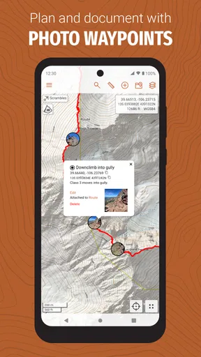
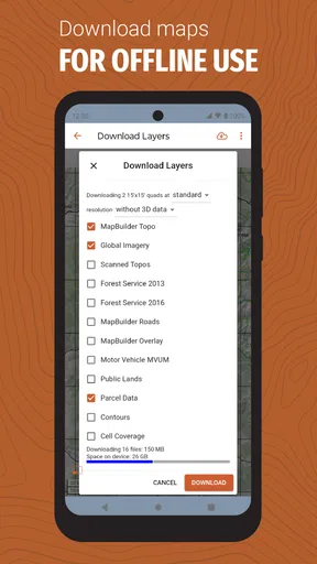
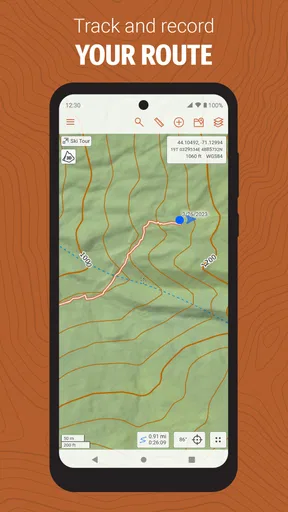
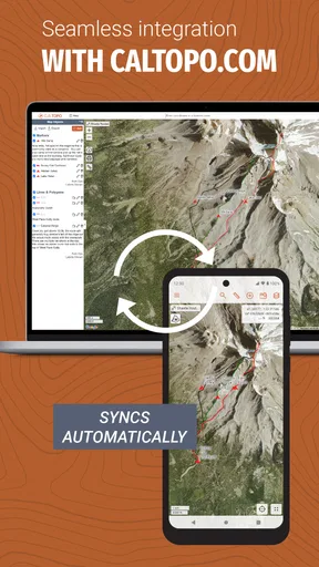
 Analysis by AppCompare
I enjoy navigation apps most when they help me make a sensible decision before I leave home, not merely show a blue dot after I am already lost. CalTopo is built for that more demanding kind of trip planning. It is a free maps and navigation app from CalTopo LLC, aimed especially at people who spend time beyond dependable roads and familiar city streets. After using it, my impression is that it rewards preparation and attention rather than trying to hide every detail behind a simple interface.
The app has a strong reputation in its category, with a 4.7 average from around 6.6 thousand ratings and more than 100 thousand installs. Those figures make sense to me: this is not a casual map viewer dressed up as an outdoor tool. It feels designed for hikers, climbers, search-and-rescue volunteers, hunters, backcountry skiers, and anyone who wants more control over terrain information than a standard road-navigation app usually provides.
What using CalTopo feels like before and during a trip
Before I head out, I use CalTopo to turn a vague idea of a route into a plan I can inspect and question; during the trip, I treat it as a reference rather than an autopilot. That distinction matters most when conditions change, so I’ll look next at how the app’s purpose and trust considerations shape the way I rely on it.
A planning tool rather than a turn-by-turn companion
My first useful distinction is that CalTopo belongs closer to a backcountry planning desk than to a conventional driving navigator. The usual alternatives are excellent when I need a quick route between two addresses, a business search, traffic awareness, or spoken directions. They are intentionally simple. CalTopo takes a different approach by putting the landscape itself at the center of the experience.
That difference affects the learning curve. A new user may open the app expecting an immediately obvious destination search and a large start button. Instead, the value comes from examining the map, understanding the terrain, and deciding what information matters for the outing. I found that extra involvement worthwhile, but I would not describe the app as effortless. It asks me to think like a trip planner.
For a short walk through a city park, I would normally choose a simpler map. For an unfamiliar trail system, a remote access road, or a route where terrain matters as much as distance, this is where CalTopo becomes more convincing. The app’s store summary, “Backcountry mapping evolved,” is brief, but it points toward the right expectation: this is made for outdoor context, not just street-level convenience.
Speed expectations on a normal planning session
In ordinary use, I judge a navigation app by how quickly it lets me answer practical questions. Where is the trailhead? What does the surrounding terrain look like? Can I identify a safer approach? Can I revisit the same area without starting from scratch? CalTopo feels most useful when I slow down enough to inspect those questions rather than treating the map as a disposable screen.
Worth Reading Before You Choose

EA SPORTS FC Mobile 26 Is a Bigger Football Game, but It Takes Time

Flipboard Shows What News Apps Must Do Beyond the Feed

Switching to Android Auto Means Rethinking Your Driving Routine

Google Calendar Makes a Crowded Week Easier to Manage

Ludo King Makes the Most of the Minutes Between Plans

Baby Panda World Brings Quick Play to Modern Phones, but Its Game Library Feels Busy
The experience can feel less immediate than a mainstream road app because a detailed backcountry map naturally contains more visual information. That is not automatically a performance problem; it is partly the cost of having a richer planning view. On a modern phone, I would expect routine map browsing to feel comfortable, while older or less capable devices may make dense map work feel more demanding. The app supports Android from version 5.1 onward, so its compatibility reaches well beyond recent phones, but broad compatibility should not be confused with identical speed on every device.
My practical advice is to prepare while you have time and a stable connection. Search for the area, inspect the route, and make your decisions before standing at a trailhead with cold hands and limited patience. That workflow makes the app feel faster because the difficult thinking has already happened. It also reduces the temptation to make an important route decision in a rushed moment.
Where heavy use can change the experience
The demanding moments are not limited to opening the app. Panning across a large region, zooming repeatedly, examining several possible approaches, and switching between different map views can all create a heavier workload than simply following a city route. The more I ask the app to display and the more rapidly I move around, the more important the phone itself becomes.
This is one reason I would avoid judging CalTopo after a quick glance at a single screen. Its strength appears during a complete planning workflow: start with the broad area, narrow down the route, inspect the difficult sections, and return to the plan later. That process is more involved than dropping a pin in a general-purpose map, but it can prevent mistakes that a faster, simpler interface would not reveal.
A realistic example is a weekend hike where the final access road is unfamiliar and the route crosses uneven terrain. At home, I would use CalTopo to study the approach, identify where the road ends, compare the planned line with the surrounding landform, and keep the intended route available for reference. At the trailhead, I would want to spend as little time as possible manipulating the phone. The app is most valuable here as preparation carried into the field, not as a replacement for judgment.
Reliability is also a recovery question
For outdoor navigation, reliability means more than “the screen opened.” I want the app to help me recover when I take a wrong turn, lose confidence in my position, or realize that the original plan no longer fits the conditions. CalTopo’s detailed mapping approach gives me a better foundation for that recovery than a basic road map, because I can reason from the landscape instead of relying only on a suggested line.
Still, no map app removes the need for a backup plan. A phone can run short of power, become difficult to use in bad weather, or be damaged. I would carry the essentials for the trip separately and treat the app as an important aid rather than my only safety measure. That is not a criticism unique to CalTopo; it is simply the responsible way to use any electronic navigation tool away from reliable infrastructure.
What I appreciate is the app’s potential to support a calmer recovery. If I miss a junction, I do not have to blindly retrace every step. I can pause, look at the surrounding map, and decide whether the mistake is minor or whether returning is the sensible choice. That kind of overview is more useful to me than a voice instruction that assumes every route is a neat sequence of turns.
Device limits matter more in the backcountry
The phone is part of the experience, so its screen size, battery condition, storage situation, and general responsiveness all matter. A large display makes map inspection easier, especially when I need to keep the broader terrain visible while following a planned line. A compact phone is easier to carry, but it may force more zooming and panning, which is inconvenient when I am wearing gloves or moving quickly.
Battery use deserves particular attention. I would not assume that a long day of active navigation will feel the same as a short planning session at home. Keeping the screen awake, using location services, and repeatedly loading or examining map information can place more pressure on a phone than ordinary messaging or reading. My preferred routine is to begin with a well-charged device, reduce unnecessary screen time, and carry a power solution suited to the trip.
The minimum Android requirement of 5.1 is helpful for people with older hardware, but an older operating system or aging phone may still provide a less comfortable experience. Compatibility tells me that installation is possible; it does not guarantee that intensive map browsing will feel equally smooth everywhere. I would be especially cautious about relying on an old phone as my sole navigation device for a remote outing.
What the current version tells me as a user
The current version is 1.28.1, and the app has been available since September 21, 2020. I mention that because CalTopo is not a brand-new experiment that I would approach without context. It has had time to establish its identity as a specialized mapping product, and the public response suggests that many users find that focus worthwhile.
At the same time, specialist apps often evolve around the needs of serious users rather than chasing the most beginner-friendly design. That can mean a more capable tool, but also a product that feels less instantly familiar than a mass-market map. I would expect to spend some time learning the controls and deciding which parts of the map are genuinely useful for my own activities. That is a reasonable trade-off, provided I am willing to learn before depending on it.
Three habits that make CalTopo more useful
My first tip is to divide planning into two passes. On the first pass, I look broadly at the area and identify the overall shape of the outing. On the second, I inspect the awkward parts: the approach, the sections where navigation may become ambiguous, and the points where turning around would be sensible. This prevents me from getting distracted by tiny details before I understand the whole route.
My second tip is to plan for failure, not just success. I would deliberately identify a retreat option or a recognizable point where I can reassess. A map is more valuable when it supports a change of plan. This is a non-obvious advantage of using a detailed backcountry tool: the preparation can include decisions for the moment when weather, fatigue, timing, or trail conditions make the original objective a poor choice.
My third tip is to keep the phone interaction simple once I am outside. I would not wait until the field to discover how the map behaves, where my saved information appears, or how much zooming is comfortable on my screen. Practicing the basic workflow at home turns the app from something I am operating into something I am consulting. That distinction matters when the surroundings are unfamiliar.
Who will appreciate it most
CalTopo is a strong fit for people who want to understand an outdoor route rather than receive a minimal instruction to follow it. Hikers planning unfamiliar terrain, climbers checking approaches, outdoor leaders preparing alternatives, and experienced users who dislike the limitations of ordinary road maps are the natural audience. It can also suit someone learning to plan more responsibly, because the map encourages attention to the environment around the route.
The free price makes it easy to try without committing money, and the Everyone content rating keeps it accessible to a broad audience. Those details do not make it a beginner app automatically, though. A person who rarely leaves paved roads may find a simpler navigation product more comfortable and more efficient. I would also steer away from it if my main needs were restaurant discovery, traffic-aware commuting, public transit, or spoken driving directions.
Another possible mismatch is the user who wants a completely passive experience. CalTopo does not appeal to me when I want the app to make every decision on my behalf. Its value comes from giving me a better basis for my own decisions. If that sounds like unnecessary work, the usual alternatives may be a better choice.
How it compares with familiar map alternatives
Mainstream map apps win on convenience. They generally make address searches, business information, car travel, and everyday directions feel immediate. Their interfaces are familiar to nearly everyone, and they are better suited to a quick trip across town. I would not replace one with CalTopo for routine errands.
CalTopo wins when the question is not simply “How do I get there?” but “What am I actually moving through, and what should I do if the obvious route is not the best one?” That is a more specialized question. The app’s advantage is not that it makes every kind of navigation better; it is that it takes backcountry planning seriously enough to deserve a separate tool.
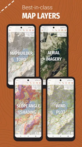
There is also a trade-off in visual complexity. A general map can be easier to read at a glance, while CalTopo may provide a more informative view that requires interpretation. I prefer the latter for serious outdoor planning, but I would not pretend it is universally superior. The right choice depends on whether I need speed and simplicity or terrain-aware preparation.
My performance verdict after using it
My overall view is positive, with one important qualification: CalTopo performs best when I use it deliberately. It feels like a capable planning companion for backcountry travel, not a magical safety net and not a universal replacement for every map app. Its speed is most satisfying when the route has been prepared in advance, its reliability is strongest when paired with sensible backup habits, and its resource demands are easiest to manage when I limit unnecessary screen time in the field.
The app’s 100 thousand-plus installs and strong average rating show that it has found a committed audience, and I can understand why. The developer, CalTopo LLC, has focused this product on a clear problem instead of trying to serve every navigation scenario at once. I value that focus, even when it means the first session takes more effort than a familiar street map.
My recommendation is simple: choose CalTopo if you want to plan outdoor routes with more awareness and control, and skip it if you only need effortless everyday directions. I would install it before a serious hike, explore the intended area while I still have time, test the workflow on my own phone, and prepare a backup for the trip. Used that way, CalTopo feels less like another map on my phone and more like a practical part of responsible backcountry preparation.
Pros
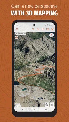
- Detailed topographic maps with excellent terrain and elevation information.
- Supports offline map downloads for hiking and backcountry trips.
- Powerful route planning
- waypoints
- and distance measurement tools.
- Includes weather
- satellite imagery
- and public land information layers.
- Useful for sharing maps and coordinating plans with other users.
Cons
- Many advanced mapping tools require a paid subscription.
- The interface can feel overwhelming for casual outdoor users.
- Offline downloads may use substantial storage on your device.
- Some map layers depend on regional availability and data coverage.
- Battery usage can increase during extended GPS and map navigation.
FAQs for CalTopo
What is CalTopo used for?
CalTopo is a mapping and trip-planning app designed for outdoor navigation, especially hiking, backpacking, skiing, hunting, search and rescue, and other backcountry activities. It provides detailed topographic maps, route drawing, waypoints, distance and elevation measurements, and location tracking. After testing its planning tools, I found it most useful for preparing trips before leaving rather than relying on it as a simple turn-by-turn navigation app.
Does CalTopo work offline without mobile service?
Yes, CalTopo can be used offline when you download the required map areas in advance. This is particularly important in remote locations where cellular coverage is unreliable or unavailable. Before starting a trip, select the region and map layers you expect to need and confirm that they are stored on your device. GPS positioning can still work without internet, but maps, weather information, and shared data may not update offline.
Is CalTopo free to use, or does it require a subscription?
CalTopo offers basic functionality at no cost, but several advanced features depend on the subscription level available for your account. Premium options may include additional map sources, expanded offline access, specialized overlays, enhanced planning tools, and collaboration features. The free version is useful for exploring the interface and creating simple routes, while frequent backcountry users may find a paid plan worthwhile after comparing the included features.
Is CalTopo suitable for beginners?
CalTopo can be used by beginners, but its large number of layers, overlays, drawing tools, and planning options may feel more complicated than a casual hiking app. New users should spend time learning the interface, downloading maps, creating waypoints, and checking elevation profiles before heading outdoors. Once those basics are understood, the app becomes much easier to use and offers more planning detail than many simpler navigation applications.
Can CalTopo be used for safety and emergency planning?
CalTopo can support safety planning by helping users study terrain, identify access points, mark campsites or hazards, measure distances, and share routes or locations with other people. However, it should not be treated as a replacement for proper navigation skills, a physical map, a compass, or an emergency communication device. Battery life, device damage, poor weather, and incorrect map interpretation can all affect reliability in the field.


